Credit: Kirill_Liv
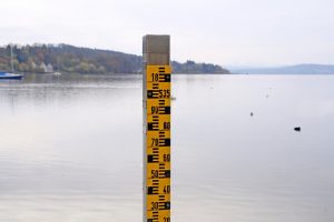
Whether you’re a homeowner or work in construction or insurance, you likely know the damage water can do to a structure. And whether you believe in global warming or not, scientists have confirmed by direct device measurement that sea levels around Florida are back on the upswing – and it could mean more frequent and severe flooding if the trend continues. The National Oceanic and Atmospheric Administration (NOAA) reports that sea levels along portions of our coast are rising by about a third of an inch every year now. While it doesn’t sound like much and is certainly invisible to the naked eye, the various gauges around the state’s 2,276 miles of tidal coastline show the waters, they are arisin’. The impacts are already being felt.
NOAA’s report “Global and Regional Sea Level Rise Scenarios for the United States,” was done in conjunction with the South Florida Water Management District and other agencies. While it acknowledges that seas have always risen and fallen throughout the centuries and in fact vary from decade to decade, that we are now in a period of steady and measurable rise that started in 2006. Why it’s happening (some say it’s general global warming, a result of higher levels of greenhouse gases that are melting icebergs, and expanding warmer ocean waters) or whether the higher rate will continue remain unknown.
Scientists at the University of Florida think they know why the rapid increase is happening: Two naturally occurring large-scale atmospheric patterns had intersected to push up the water off the Southeast coast, causing a “hot spot” of sea-level rise. The area extends from North Carolina’s outer banks south to Miami. The UF report “East Coast’s rapidly rising seas explained” shows that from 2011 to 2015, the sea level along the southeastern American coastline rose six times higher than the average global increase. Regardless of the cause – natural or otherwise – both the scientists at UF and NOAA say if sea level rise doesn’t level out, Florida’s coastal communities will be in for some trouble.
The NOAA report’s mid-range projections estimate that by 2030, Florida sea levels will be up to 17 inches higher than they are today. The communities with the highest projected rise are Jacksonville’s Mayport community, Fernandina Beach, and Daytona Beach. Just a 9-inch rise in sea level would be enough for NOAA to issue 25 times more coastal flooding advisories than it does today, as seawater is pushed inland along waterfronts and in lower-lying areas of major rivers connected to the sea. By 2070, mid-range projections call for levels from 8 inches to 5.5 feet higher than today, if the current trend continues.
But the impacts are already being felt today. Clay Henderson, Executive Director of Stetson University’s Institute of Water and Environmental Resilience and a resident of New Smyrna Beach, was recently quoted in the Insurance Journal as saying “Until the last couple of years, the only time the water would have come over the seawall would have been for a named tropical event or one of the extraordinary nor’easters,” but in the fall of 2015 and 2016, he said “the water came out of the banks on cloudless, breezeless days.”
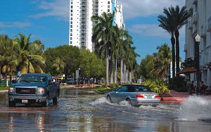 Parts of Miami Beach, too, are impacted with some minor street flooding occurring on perfectly sunny days. Officials there are spending nearly half a billion dollars to put check valves on storm drains and elevate certain roads and sidewalks susceptible to flooding. Building code changes are also in the works. Some lunar high tides and storms are now strong enough to reverse the flow of drainage canals, flooding neighborhoods.
In the Florida Legislature, Senator Jeff Brandes has taken notice and is on the forefront of efforts to provide greater funding for flood mitigation. This week he filed SB 158, which would allow flood mitigation projects to be funded by the Florida Communities Trust to reduce flood hazards.
For now, the NOAA report should raise awareness and provide data that can be used in future planning decisions, from residential & commercial development, to mitigation, to emergency management. The greater Tampa Bay area was cited in this recent Washington Post article as one of the most vulnerable in the United States to flooding and damage if a major hurricane ever scores a direct hit.
For a peninsular state surrounded by tidal waters, whose economy and very existence thrive on them, those of us who live and do business in Florida need to be aware of this latest information and plan and act accordingly.