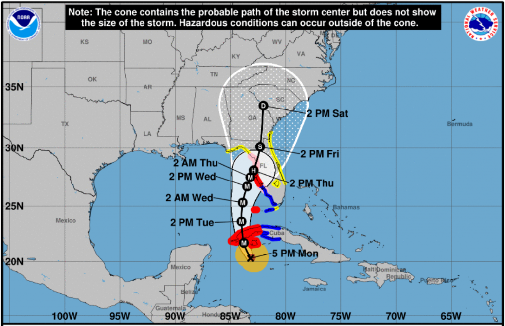
September 26, 2022, PM Update – Hurricane Ian was born early this morning south of Cuba where it remains this evening as a Category 2 storm – and strengthening. The entire state of Florida into Georgia is expected to be impacted over the next few days as it becomes an anticipated major Category 3-4 storm. Landfall is currently expected Thursday afternoon on Florida’s west coast north of the Tampa Bay area but the forecast has been shifting and is expected to continue evolving. The especially vulnerable Tampa Bay, including Hillsborough and Pinellas counties haven’t been hit with a major hurricane in a century. We’ll focus on the insurance impacts of the storm first, and then the latest from NOAA on Ian’s conditions as of 5pm today and forecast.
Insurance Impacts:
Adjusters: The Florida Department of Financial Service (DFS) Division of Agent and Agency Services has activated the state’s emergency public adjuster system to allow licensed out-of-state adjusters to assist consumers in adjusting insurance claims following the storm. Citizens Property Insurance has made a commitment that it does not intend to compete with the private insurance industry on the contracted price for such adjusters, as has sometimes been the case in previous storms.
Speaking of adjusters, there have been problems in past storms receiving clearance from local law enforcement to go into impacted areas to begin the insurance claims process. The statewide private sector re-entry program delineates what documents you will need to present to local officials when seeking re-entry into an impacted area. Click here to learn more. Please let us know if you encounter difficulties from skeptical local authorities.
Insurance Consumer Response: The DFS has interfaced with the Top 25 insurance carriers in Florida to confirm and coordinate with companies on preparations to mobilize disaster response and recovery operations immediately following the storm. It’s Division of Investigative and Forensic Services (DIFS) has activated its Emergency Operations Center to coordinate insurance consumer protection and fraud prevention missions following the storm. DIFS arson and explosives teams will also support US&R missions once activated.
Ian Insurance Claims: LMA today issued a press advisory with Hurricane Ian Claims Damage Tips for Florida and national news media to consider in their coverage of the storm. We stressed the importance of staying safe prior to and during the storm, how to handle any damage and prepare an insurance claim, and the best methods for filing claims. We welcome your feedback.
Emergency Management Response: The State Emergency Operations Center has been on Level One Alert since yesterday. FEMA has approved the pre-landfall emergency declaration and request by Governor DeSantis to the President through FEMA’s Southeast Regional Administrator. That means Florida’s entire 67 counties will be eligible for 75% federal cost share for preparation and related expenses. Specific operations underway are outlined below at the bottom of this update. Here’s an updated contact list of County Emergency Managers and Florida DEM Regional Contacts.
Business and Industry Concerns: LMA has been participating in daily state and FEMA conference calls with business and industry on preparation and response to the storm. There was concern expressed on today’s calls on the need for clear communication about access to get into affected areas to deliver food and other needed supplies after the storm as well as which roads and routes in general are open. In Tampa, home to several chemical processing facilities, an industry representative shared that the industry is determining which facilities may be most vulnerable to the storm and taking necessary precautions. A representative for an oil refinery and distribution center said that plans have been developed to evacuate the facilities as needed, while keeping key employees close by to resume operations once it’s deemed safe to do so.
Current Warnings/Watches as of 5pm today:
Hurricane Warning from Englewood north to the Anclote River in Tarpon Springs, including all of Tampa Bay.
Hurricane Watch from the Anclote River north to the Suwannee River and from Englewood south to Bonita Beach.
Tropical Storm Warning from the Lower Florida Keys from Seven Mile Bridge westward to Key West and from Flamingo to Englewood.
Tropical Storm Watch from Seven Mile Bridge to the Channel 5 Bridge; Lake Okeechobee; North of the Suwannee River to Indian Pass; and on Florida’s east coast from Jupiter Inlet to Altamaha Sound in Georgia.
Storm Surge Warning from Anclote River southward to and including all of Tampa Bay
Storm Surge Watch from the Card Sound Bridge westward to Key West; the Dry Tortugas; Florida Bay; the Anclote River north to the Aucilla River; and on Florida’s east coast from the Flagler/Volusia County Line north to the Altamaha Sound; and all of the St. Johns River.
Winds:
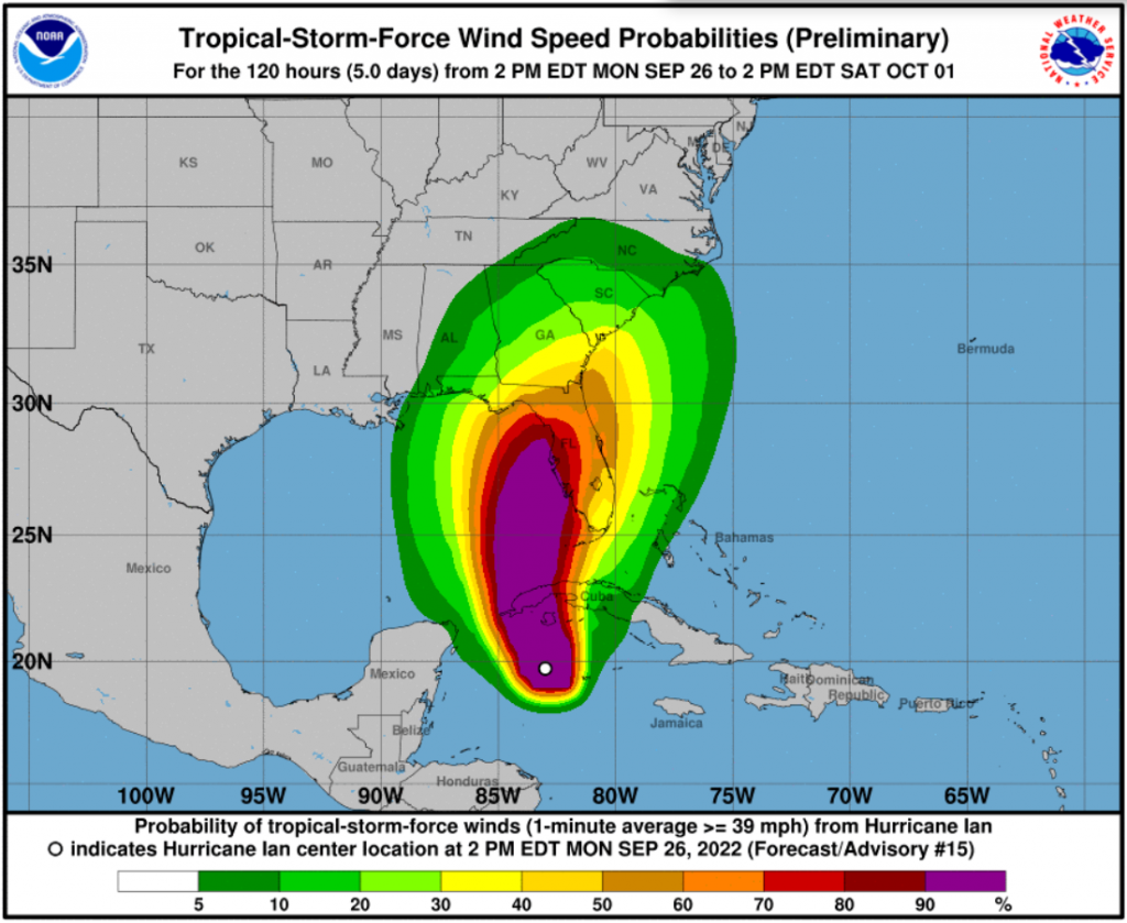
Maximum sustained winds are now near 100 mph with higher gusts and rapid strengthening is expected over the next two days. Tropical storm conditions are expected in the warning area in the lower Florida Keys and are possible in the watch area tomorrow (Tuesday). Hurricane conditions are expected along the west coast of Florida within the Hurricane Warning area on Wednesday, with tropical storm conditions possibly beginning by tomorrow (Tuesday) night. Hurricane conditions are possible in the watch area beginning on Wednesday, and tropical storm conditions are possible in the watch area on Wednesday into early Thursday.
Rain:
Ian is expected to bring 4-6 inches of rain to the Florida Keys, with local maximums up to 8 inches. Coastal Southwest and Southeast Florida will see 4 to 6 inches with local maximums up to 10 inches. Central West Florida (including Tampa Bay) are expecting 6 to 12 inches, with local maximums up to 20 inches. Northeast Florida will see 6 to 10 inches, with local maximums up to 12 inches. The remainder of the Central Florida Peninsula is expected to get 4 to 8 inches.
Heavy rainfall is expected to affect the Southeast U.S. Friday and Saturday. Widespread considerable flash and urban flooding, and prolonged significant river flooding impacts are likely mid-to-late week across central and northern Florida, southern Georgia, and coastal South Carolina.
Storm Surge:
The combination of storm surge and the tide will cause flooding along the coast and moving inland. The Anclote River south to Longboat Key, including all of Tampa Bay could see water reach heights of 5-10 feet above ground if the peak surge occurs at the time of high tide. Longboat Key south to Englewood could see heights of 5-8 feet, with other surge watch areas receiving water heights of 2-5 feet.
“Do not be fooled by the forecast of weaker winds. The storm surge can still be massive, higher than anything seen in modern times,” tweeted Bryan Norcross, a Fox Weather hurricane specialist who made his reputation for making sure we realized the seriousness of Mother Nature during Hurricane Andrew 30 years ago.
Evacuations:
Evacuations began earlier today in the Tampa Bay area, specifically in Hillsborough, Pinellas, and Manatee counties. Mandatory orders are in effect for those living in Hillsborough’s Evacuation Zone A with voluntary evacuations in Zone B; likewise for residents in Pinellas County and Manatee County. Governor DeSantis suspended tolls in the Tampa Bay area, Polk County, Alligator Alley, and parts of the Panhandle. Shelters have begun opening in effected areas.
We remind those in the path of the storm of the wise adage, “Run from the water, hide from the wind,” especially given the lessons from flooding in the Carolinas from Hurricane Florence. Please make sure you are finishing your emergency preparations with the hope that we won’t need them but the confidence that we’re ready.
Click here for the full National Hurricane Center briefing with maps. You can also review our past Hurricane Updates.
Please know that we at Lisa Miller & Associates are here 24/7 for you …don’t forget it. It may sound trite but we are all in this together, my friends and colleagues. Please prepare and be aware!
Lisa & the LMA team
(Here’s the latest News from the Governor’s Office of specific state preparedness actions:)
Florida Division of Emergency Management (FDEM)
- FDEM has activated the State Assistance Information Line (SAIL) to provide an additional resource for Floridians to receive up-to-date information regarding Hurricane Ian. Residents and visitors can call this toll-free hotline at 1-800-342-3557.
- FDEM is deploying several hundred shelter support staff to address staffing needs in counties that have opened their Special Needs hurricane shelters.
- FDEM is leading the State Emergency Response Team (SERT) for the Hurricane Ian response.
- The Division has received more than 500 resource requests for Hurricane Ian and fulfilled 466. Requests are currently being processed and are either en route or being mobilized. This includes the coordination of resources such as: trucks of food and water, generators and water pumps.
- Five Florida Urban Search and Rescue (USAR) Teams are activated, and will be prepared to deploy to impacted areas. An additional three federal USAR Teams are standing by to assist.
- Over 27,000 power restoration personnel are on standby to assist impacted areas after the storm.
- FDEM has begun setting up a Logistical Staging Area in Polk County and is identifying potential additional staging areas and points of distribution to ensure food and water are readily available if counties request it.
- FDEM has loaded 360 trailers with over 2 million meals and over one million gallons of water in preparation for distribution to impacted areas.
- FDEM is in constant communication with all 67 county emergency management offices and state agencies to coordinate protective actions and needed resources ahead of potential storm impacts.
- FDEM is coordinating with utilities to ensure crews are prepared to respond and restore power. Utility providers have more than 25,000 linemen staged and prepared for power restoration efforts.
Florida National Guard
- Following Governor DeSantis’ authorization, a total of 5,000 Florida Guardsmen are being activated to State Active Duty and pre-positioned at armories across the state for Tropical Storm Ian response operations. 2,000 Guardsmen from Tennessee, Georgia and North Carolina are also being activated to assist.
- The Florida National Guard is currently supporting missions including staffing and supporting the State Logistics Response Center (SLRC) in Orlando.
- In addition, the Florida Guard has mobilized and is on standby with five Route Clearance Teams and Aviation assets.
- The Florida National Guard is well-equipped, with assets including high-wheeled vehicles, helicopters, boats, generators and more.
Florida Department of Law Enforcement (FDLE)
- FDLE’s mutual aid team is coordinating evacuation missions in Cedar Key and security for ambulance response teams who are staging prior to Hurricane Ian.
Florida Department of Health (DOH)
- DOH has prepared for Special Needs Shelter operations to begin in areas of anticipated landfall. A press release has been sent with additional information on special needs shelters.
- The State Surgeon General has signed a letter to allow staff of the Department and Agency for Health Care Administration to travel past any potentially issued curfews across state lines to conduct any necessary health and safety actions.
- DOH continues to coordinate across 67 county health departments on any necessary preparation resources, in coordination with county emergency managers.
- DOH has coordinated with the Office of Insurance Regulation to distribute an alert regarding permitted early prescription refills during a State of Emergency. This alert was sent to health insurers, managed care organizations, health entities, and licensed health care providers. The alert can be found here.
- DOH is supporting Special Needs Shelter operations in areas of anticipated landfall.
- Nearly 300 ambulances, paratransit busses, and support vehicles are being deployed in areas of anticipated landfall.
- DOH has coordinated with Federal partners to support the deployment of nearly 100 individuals through various health and medical teams. These teams stand ready in Orlando, Atlanta, and Warner Robbins Air Force Base in Georgia.
Agency for Health Care Administration (AHCA)
- AHCA has activated the Emergency Patient Look-Up System (E-PLUS). Special Needs Shelters for 16 counties are able to utilize the system to retrieve patient medical records. E-PLUS is also available to assist medical providers and emergency response personnel with locating missing or displaced persons after the storm.
- AHCA is requiring health providers to update the Health Facility Reporting System by 10 AM daily to ensure each facility is taking the appropriate precautions to ensure patient safety.
- AHCA has completed 124 onsite visits in Nursing Homes and ALFs that were previously identified as out of compliance with generator requirements. As of today, 100% of operating long-term care facilities have a generator on-site. The Generator Status Map for long-term care facilities is available here.
- AHCA has reminded all Medicaid Managed Care Plans of the requirement to allow 30-day emergency prescription refills of maintenance medication.
Hurricane Ian Update of September 26, 2022, PM Update