New FEMA maps released in SW Florida

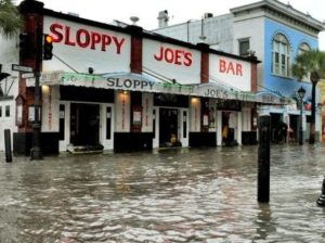
Flooding on Duval Street in Key West, FL
Hurricane Dorian served as another reminder of the startling number of Americans at risk of flooding but who have no flood insurance. Even worse are the growing numbers shedding coverage. Meanwhile, in Southwest Florida and the Keys, hit hard by 2017’s Hurricane Irma, FEMA is premiering updated flood maps this month. Key West’s low risk X Zone is shrinking by two-thirds. (Who knew they even had an X Zone in the Keys?!)
During Hurricane Dorian’s trip up the eastern seaboard from Florida, Milliman released an analytics study showing only 13% of the 1.9 million single-family homes in its path and at risk of flooding have federal flood insurance. Our friend and actuary extraordinaire John Rollins summed it up in a New York Times article: “Many more people should have flood insurance. The take-up rate is minuscule. And yet the flood risk is there,” he said. In North Carolina where Dorian made landfall, less than 10% of at-risk homes were estimated to have coverage.
Meanwhile, an E&E News analysis showed a steep drop in the number of federal flood insurance policies in the 59 counties in Florida, Georgia, North Carolina and South Carolina that were under evacuation orders related to Dorian. The policy count fell from 734,000 polices in 2011 to 509,000 policies this month – a 31% decline. We know here in Florida that the number of private flood insurance policies is growing rapidly and expected to reach 100,000 by the end of this year. It’s unknown whether or how many of those who dropped their federal polices got private policies instead.
The flood threat isn’t diminishing either with our recently busier hurricane and spring rainfall seasons. A report in Nature by authors affiliated with Princeton University and MIT, predict 100-year floods may instead occur annually along the mid-Atlantic and New England coastline and once every 30 years along the Southeastern US coastline.
Southwest Florida and the Florida Keys are no strangers to flooding, having been swamped by Hurricane Irma’s double landfall two years ago this month. FEMA is out with its updated flood maps for Lee and Collier Counties at public meetings. Some people currently in high risk zones will now be out and other currently out will now be in. One emergency manager shared with residents that just one inch of water in your home costs about $25,000 in damage – so flood insurance has value!
The Florida Keys maps, are a little different story. New FEMA maps show the X Zone (low risk) area in Key West where homeowners aren’t required to have flood insurance is shrinking to one-third of its current size. So folks there with mortgages are going to have to buy flood insurance – or do the math and spend the money instead raising their structures higher out of harm’s way.
Up in Washington D.C., lawmakers have punted again and approved a 13th short-term reauthorization of the National Flood Insurance Program (NFIP) through November 21. This occurred in the same week that a U.S. House Financial Services subcommittee heard how our increasing storms exacerbate the inadequacy of NFIP risk data and maps.
LMA Newsletter of 9-23-19

