Plus Miami-Dade’s flood wall idea
 Some Central Florida local governments are reviewing their stormwater infrastructure and practices following Hurricane Ian’s heavy flooding, Miami-Dade County is back to the drawing board on a potential multi-billion dollar federal flood project, and FEMA has released its new Climate Projection Portal. It’s all in this week’s Flood Digest.

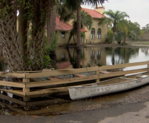
Flooding in the Stone Island community of Volusia County from Hurricane Ian’s rains
Flood Vulnerability Questions: The Orlando Sentinel reports that Orlando and Orange County are undergoing extensive reviews of their stormwater infrastructure and policies in the wake of Hurricane Ian. The Cat-4 hurricane produced a consistent 12-13 inches of rainfall with some areas seeing as much as 16 inches. The stormwater systems are designed to handle a 10-year storm for six hours. Seminole County next door saw huge deluges and utilizes a 25-year, 24-hour standard in its retention pond design requirements. Up to 22 inches fell in Volusia County. Ian was rated a 1,000-year event by NOAA standards and so easily overwhelmed many storm sewers and retention ponds. The paper reports that In July and August alone, the U.S. had six 1,000-year flooding events by NOAA standards in Kentucky, Illinois, Mississippi, St. Louis, Dallas and Death Valley, California.

Rendering of Army Corps of Engineers’ previously proposed flood wall in downtown Miami. Source: Curtis + Rogers Design Studio and the Miami DDA
Miami-Dade Flooding: Back in February of 2020 we shared what was one of the most fanciful flood mitigation ideas to date in South Florida: The U.S. Army Corps of Engineers was proposing to build a 10-13 foot wall along the coast. Well that didn’t go over very well (see the artist’s conception at right and in this updated Miami-Herald story) so now the Corps has just finished a new series of public hearings to find out what other flood control measures may be more acceptable. The Corp’s Miami-Dade Back Bay Coastal Storm Risk Management Feasibility Study comes as the county is in line for a potential multi-billion federal project to help not only protect the vulnerable area from future hurricanes, but from the current period of gradual sea level rise that includes so-called “sunny day flooding” and King Tides.
 New Climate Projections Portal: FEMA has launched the Climate Risk and Resilience Portal (ClimRR), in cooperation with the U.S. Department of Energy and AT&T. The portal provides free access to the latest science in climate projections to help improve preparedness for future climate extremes. ClimRR uses modeling that is among the most sophisticated methodologies worldwide, per FEMA. The portal also gives state and local emergency managers and community leaders free access to localized data about future climate risks that can be used to explore resilience strategies. Initial hazards included in ClimRR are temperature, precipitation, wind and drought conditions. Additional risks, such as wildfire and flooding, will be added in the coming months.
FEMA says climate projections from ClimRR can be overlayed with community and infrastructure information sourced from the Resilience Analysis and Planning Tool (RAPT). Combining data from ClimRR and RAPT allows users to understand local-scale climate risks in the context of existing community demographics and infrastructure, including the location of vulnerable populations and critical infrastructure.
LMA Newsletter of 11-21-22

