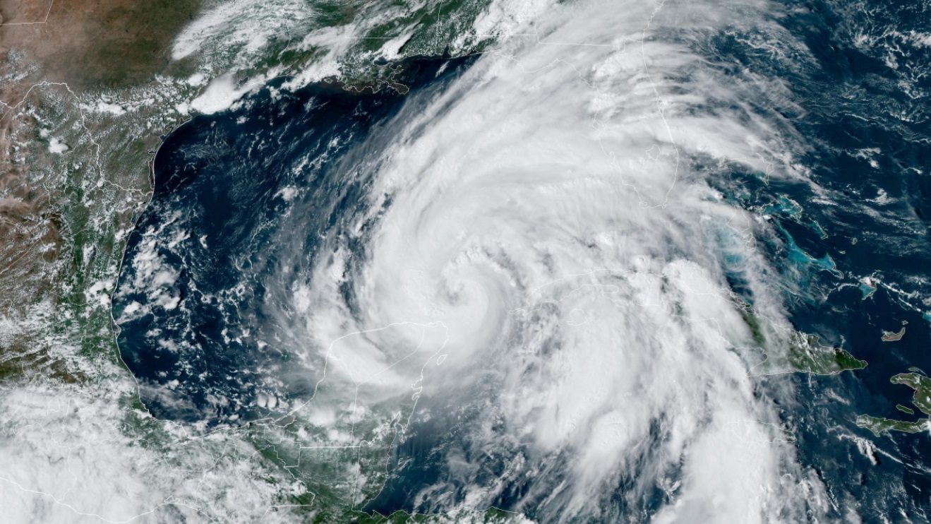
A satellite image of Hurricane Helene moving into the Gulf of Mexico on September 25, 2024. Courtesy, NOAA
September 25, 2024 PM Update – Hurricane Helene is strengthening this evening, with a new forecast that calls for even more rain and higher storm surge than originally anticipated, described as “catastrophic” and “not survivable.” Entire counties are under mandatory evacuation orders ahead of the storm. This was the last full day of storm preparation for residents and emergency management officials alike ahead of tomorrow evening’s expected landfall somewhere in the Big Bend area of Florida. Initial insurance predictions are for “moderate” losses in the single-digit billions, given the rural nature of where the storm is expected to go.
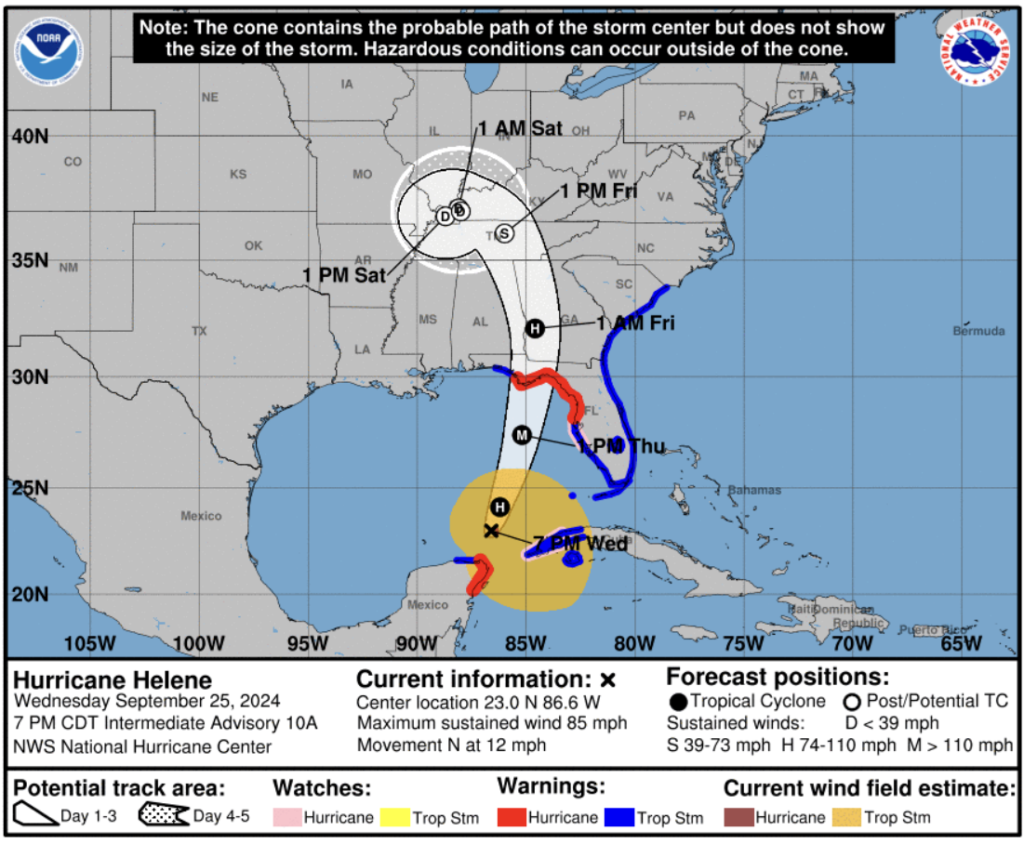
The wind has picked-up tonight in the Florida Keys with the first U.S. effects of Helene, which formally became a hurricane this morning off Mexico’s Yucatan Peninsula. As of 5pm, Helene was a Category 1 hurricane with maximum sustained winds of 85 mph. Rapid strengthening is expected into the overnight hours tonight to become near major hurricane strength (111mph) by morning and then “potentially” becoming a Category 4 hurricane (130-156 mph winds) tomorrow afternoon as the system sweeps along the West Central Florida (Tampa Bay) coast toward a landfall still predicted to be somewhere between Mexico Beach and Tarpon Springs. Florida’s state capital of Tallahassee, is right in the middle of the forecast path cone.
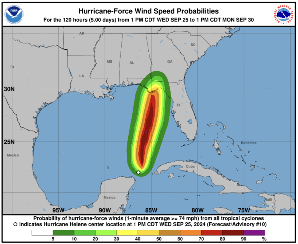
But Helene is not only strengthening, it’s becoming larger. The hurricane warning now spans 21 counties, some of them entirely inland counties. So this is not going to be just a coastal event. A tropical storm warning extends to all but 70 miles of Florida’s entire coastline (Georgia and South Carolina are included as well) due to the size of Helene as well. “Helene’s forecast radii are at the 90th percentile of major hurricane size at similar latitudes, and therefore storm surge, wind, and rainfall impacts will likely extend well away from the center and outside the forecast cone, particularly on the east side,” wrote the National Hurricane Center today.
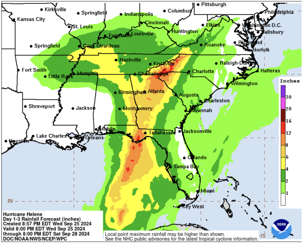
The National Hurricane Center said the rainfall risk has continued to increase as well, with 12-16 inches of rain now expected with isolated heavier totals. The Big Bend area, including Tallahassee, is expected to get among the most rain. The Weather Prediction Center has now upgraded parts of that area, including Tallahassee, to a “high risk” of flash flooding. Other parts of North Florida will see a potential 6-12 inches of rainfall. There’s also a threat of tropical tornadoes, beginning tomorrow (Thursday) afternoon.
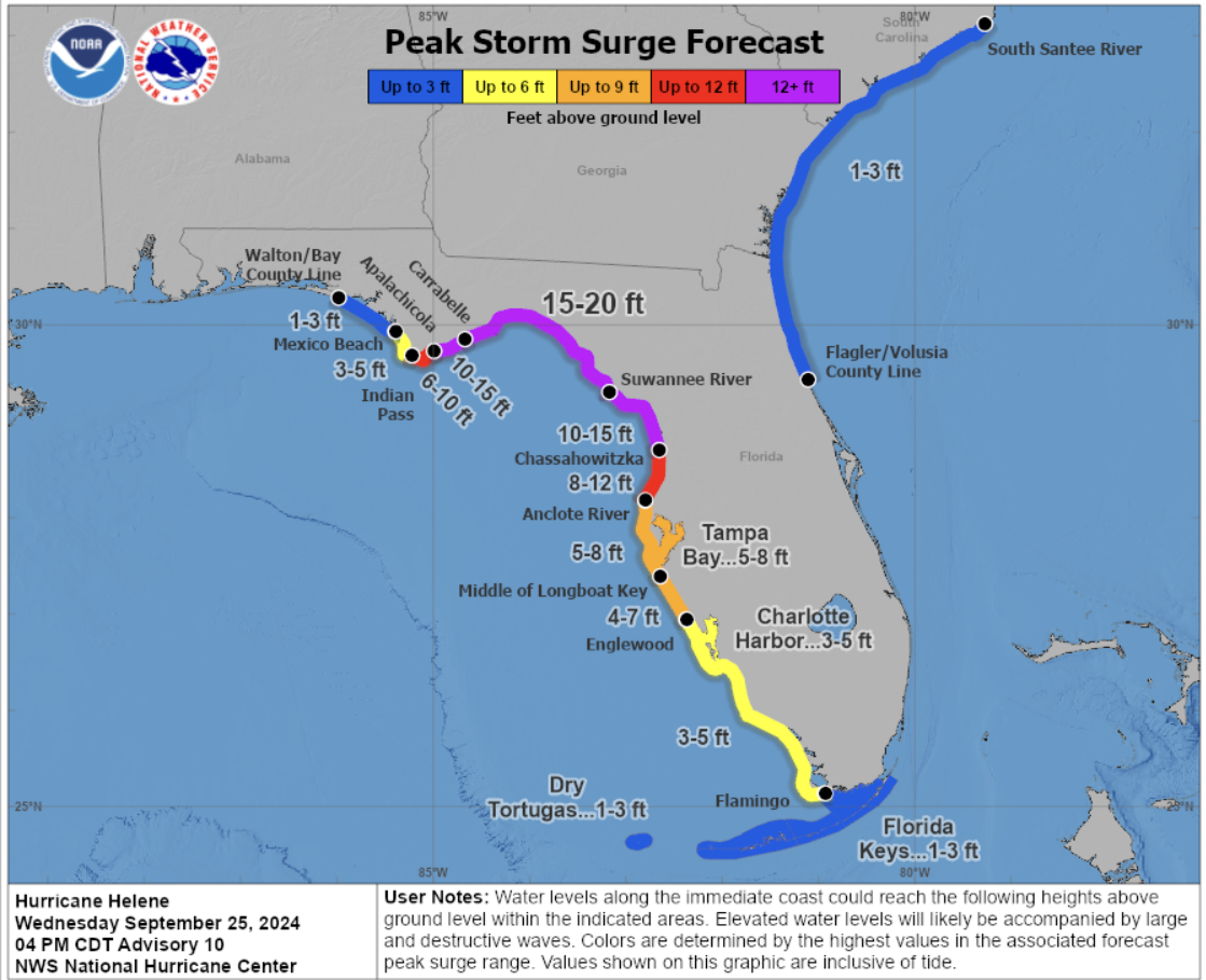
Forecasters tonight have also increased the anticipated level of storm surge from its previous 10-15 feet to now 15-20 feet in the most impacted areas (which will be somewhere between Carabelle, Florida east to the mouth of the Suwannee River, which is just south of Horseshoe Beach, close to the area where Hurricane Idalia made landfall in August 2023). “This is a significant and catastrophic surge event that’s unfolding across our coastline,” said one hurricane center forecaster.
Again, the forecasters are increasingly warning that this is not just a coastal event, emphasizing the surge will travel many miles inland, into Jefferson and Taylor Counties, “inundating many of our coastal roadways, some of our major US Highways.” That includes Highway 98 in portions of those counties as well as Wakulla County, by way of the Wakulla, St. Marks, Steinhatchee, and Suwannee Rivers. Farther south along the Gulf Coast, where the surge forecast is less, at 10-15 feet, they are forecasting “significant inundation” to Cedar Key, all the way down to Levy County. “People need to take this seriously,” the hurricane center said.
We’re told that the hurricane center forecasters have high confidence in the surge and where it will be worst, as there has been mounting concern about the relatively low-lying Tampa Bay area. The storm is not expected to make what would amount to a hard right turn to deliver that worse case to Tampa Bay. However, significant flooding is likely even with the 10-15 surge that is forecast there.
Preparations: Mandatory evacuations have been issued in about 10 Gulf Coast counties with voluntary or partial evacuations in several others. Counties with those mandatory evacuation orders have been going door to door today with Sheriff’s deputies to inform residents it’s time to get out. There has been reluctance by some to leave. Those are the very people that disaster managers will have to check on after the storm, to see if they have survived and need assistance.
On that threat of storm surge and expected inland flooding in some areas, “I would heed those warnings,” Governor DeSantis said at a morning news conference in Tampa. “You can hide from the wind – and there will be significant wind from this storm – but you’ve got to run from the water.” While Helene’s exact intensity at landfall remains to be seen, the Governor urged residents to prepare for the worst-case scenario, including in areas outside of the storm’s path. “We are going to have significant impacts from this storm,” he warned, stressing again preparedness. Wakulla County Sheriff Jared Miller, who has been implementing a mandatory county-wide evacuation, put it another way. “A 12-foot storm surge would be a historic event and not survivable for those along coastal or lowing areas that would be affected,” he said in a social media post.
Since Sunday, Florida Emergency Management Director Kevin Guthrie and his Tallahassee team at the state Emergency Operations Center have been coordinating with the 67 county emergency managers, moving assets and putting things in place to help residents survive the storm and have the resources available to deal with the aftermath. (Here’s the complete list of statewide evacuation orders.)

Traffic gridlock on westbound Interstate 10 tonight from those fleeing Florida’s Big Bend and Hurricane Helene’s pending landfall, September 25, 2024
Shelters are open tonight or will open in the morning in most of those 21 counties under a hurricane warning. Florida High School has been designated as a special needs shelter for surrounding counties who expect mass evacuations. It opened this evening and can handle 613 people. Leon County (Tallahassee) has seven regular shelters that also opened tonight. Guthrie said he has plans to consolidate all the shelters after the storm at the city’s large Donald Tucker Convention Center in downtown Tallahassee. (Here’s the complete list and current status of shelters.)
Tallahassee is a heavily-treed city and officials here are preparing for the possibility of heavy damage to its electric grid. Mayor John Daily said he “expects significant damage if it is a Cat. 2 or higher that comes directly to Tallahassee.” Mutual aid crews from 9 states, including Missouri, Louisiana, Ohio, North Carolina, Arkansas, Pennsylvania, Kentucky, Michigan, and Florida, arrived today. By the end of today, the city said it had tripled its resources for storm response and recovery.
A complete list of the state’s preparedness efforts is at the end of this report.
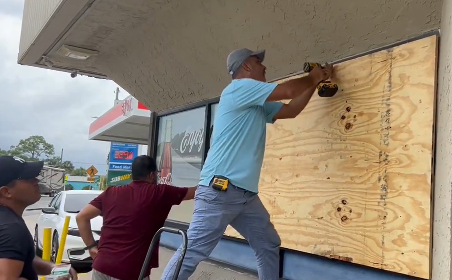
A Carabelle, Florida convenience store boards-up its windows ahead of Hurricane Helene, September 25, 2024
Disaster Declarations: The White House has approved the Governor’s initial request for a federal emergency declaration for 41 of Florida’s 67 counties. FEMA will now provide direct and reimbursed assistance – the Category B aid – up to 75% of the state and local cost, for the mass care, evacuation and shelter of residents in the following 28 counties: Bay, Calhoun, Charlotte, Citrus, Collier, Dixie, Franklin, Gadsden, Gilchrist, Gulf, Hernando, Hillsborough, Jackson, Jefferson, Lafayette, Lee, Leon, Levy, Liberty, Madison, Manatee, Monroe, Pasco, Pinellas, Sarasota, Suwannee, Taylor and Wakulla counties. In addition, FEMA is authorized to provide direct emergency protective measures, at 75% federal funding, for the additional 13 counties of Alachua, Bradford, Columbia, Escambia, Hamilton, Holmes, Marion, Okaloosa, Santa Rosa, Sumter, Union, Walton and Washington. John Brogan has been named the Federal Coordinating Officer for federal recovery operations in the affected area.
Insurance Impacts: Comparatively speaking, insurance modeling suggests that Helene will make landfall in a sparsely populated area. The Tallahassee metropolitan area aside (about 260,000 residents) the rest of the area is rural and despite the storm’s intensity, its impact on the insurance industry is anticipated to be moderate. But (again) the storm’s actual impacts are expected to extend far beyond the cone of uncertainty. The most significant effects are on the right side of the storm track and the location of landfall. While a record storm surge is expected at the coast, its fast forward motion will create a speeder surge, but one whose impact is less that if it were a slower-moving storm.
Gallagher Re Analytics today released a Hurricane Commentary with a preliminary analysis on the impacts from Helene. The global reinsurance broker said Helene could generate $3 billion to $6 billion in private insurance losses and another $1 billion in National Flood Insurance Program (NFIP) and crop insurance claims.
“Landfall in the Big Bend or Panhandle region of Florida as a major hurricane (Category 3, 4, or 5) has historically translated to insured losses in the low single-digit billions,” the analysis said. “But Helene is not a typical storm. Given Helene’s very large wind radius, this would still bring hurricane-force wind gusts and high storm surge to coastal areas in the heavily populated Tampa Bay area, tropical storm force winds across most of the Florida peninsula, Georgia, the Carolinas, Tennessee and southern Appalachia. This initially suggests that Helene’s private insurance market losses should be expected to land in the range of ($3 billion to $6 billion). This is subject to change. Additional losses attributed to the National Flood Insurance Program and the USDA’s (U.S. Department of Agriculture’s) crop insurance program may approach ($1 billion).”
The Florida Office of Insurance Regulation (OIR) Tuesday issued a Notice to Industry on Hurricane Preparedness and Claims Handling. It highlights important regulatory requirements and best practices to ensure efficient and proper claims handling pursuant to Florida law. It includes a section on insurance companies implementing their claims-handling manuals. Companies are required to acknowledge receipt of a claim within seven calendar days. Insurers must then make a claim determination within 60 days of receiving notice of a claim, notwithstanding a delay caused by factors beyond the control of the insurer. It also includes handy reminders of preparedness measures within the insurance company.
On a final note, the South Florida Sun Sentinel published this list of live webcams stretching along Florida’s Gulf Coast, where you can watch some of the impacts of Hurricane Helene.
Click here for the full National Hurricane Center briefing with maps. Visit FloridaDisaster.org/Updates for the very latest state disaster management information. That includes a complete list of statewide evacuation orders and a list and current status of shelters. You can also review our past Hurricane Updates and subscribe to receive future updates in your inbox.
Please know that we at Lisa Miller & Associates are here 24/7 for you. It may sound trite but we are all in this together, my friends and colleagues. Please prepare and be aware!
Lisa & the LMA team
(Here’s the latest news from the Governor’s Office on specific state preparedness actions and a list of mobilized resources:)
State Preparedness Efforts
- The Florida Division of Emergency Management (FDEM) activated the State Emergency Operations Center to a Level 1 on Tuesday, September 24 and is leading coordination efforts for the State Emergency Response Team.
- FDEM is hosting twice-daily calls with all 67 counties to identify needs and to ensure the state is prepared to respond quickly and efficiently.
- Additionally, FDEM is coordinating with state agencies, non-governmental organizations, and private sector partners to facilitate ongoing resource requests for counties, including requests for water, generators and support personnel.
- Over 800 missions are being facilitated by the State Emergency Response Team to assist counties in their preparation efforts. These missions accomplish vital tasks like prestaging response resources, protecting critical infrastructure facilities like hospitals and utility stations, and coordinating personnel statewide.
- There are 35,000 shelf-stable meals being staged near the anticipated area of storm impact, ready to deploy for response.
- Seven Urban search and rescue task forces are ready to deploy to as soon as weather conditions permit.
- The Florida National Guard (FLNG) has mobilized nearly 3,500 Soldiers and Airmen in preparation for Hurricane Helene, and is able to surge to 5,500, if needed.
- The FLNG is focused on preparing and staging forces ahead of the storm, assigning areas of responsibility, and placing liaison officers in the projected affected counties.
- The FLNG is postured to provide logistics support, law enforcement support, route clearance, search and rescue, commodity distribution, flood mitigation, aviation and other support as needed by the state.
- The Florida State Guard (FSG) has prepared the following:
- 250+ Soldiers ready to deploy.
- 10 shallow water vessel boat teams
- 7 flat-bottom-flood rescue skiffs
- 2 amphibious rescue vehicles
- 12 UTV’s
- 15 Cut and toss crews
- 7 search and rescue teams
- 1 UH-60 Blackhawk for daytime aerial assessment and logistics missions
- The Florida Department of Law Enforcement (FDLE) mutual aid team is at the State Emergency Operations Center coordinating law enforcement missions. FDLE logistics teams are moving and staging assets.
- FDLE has moved all assets, including aircraft, and is ready to respond for reconnaissance and damage assessments.
- FDLE members are coordinating with our partners to immediately respond to impacted areas once it is safe.
- FDLE agents are assigned to all activated county emergency management centers.
- FDLE has prepared all back-up satellite and communications systems. Portable towers have been staged for emergency communications.
- FDLE has ten squads of agents ready to respond.
- The Florida Fish and Wildlife Conservation Commission (FWC) continues to monitor Hurricane Helene’s path and has readied high-water vehicles and all other storm response resources statewide so they may be rapidly deployed to assist Floridians in need in the event of damage or flooding.
- Contingency plans and pre-storm staging areas based on forecasted landfall locations have been developed and remain flexible based on the storm’s projected path.
- 53 FWC officers and two support staff are ready to deploy and respond with a variety of specialized equipment as necessary, such as:
- 6 Airboats
- 8 Shallow draft boats
- ATVs/Side-by-sides
- 54 high-water capable four-wheel drive vehicles
- 3 aerial surveillance drones
- 10 high-water capable swamp buggies/Fat Truck/UTVs
- 3 SOG support trailers
- 3 BERG self-sustainment container units
- 3 Hygiene trailers
- 2 Mobile command units
- 5 Generators
- 2 Water trailers
- 1 Fuel trailer
- The FWC has identified multiple teams of officers from areas of the state unlikely to be severely affected by the storm to deploy to areas that may be seriously impacted.
- These teams are mobilizing self-sustainment equipment to establish an effective base of operations immediately following the storm’s passing.
- These officers and assets are in addition to local FWC officers already assigned to any affected areas. FWC officers have the training, capacity, equipment, and experience to effectively respond to natural disasters.
- FWC Captive Wildlife Investigators have contacted captive wildlife facilities in the projected path to assist as needed.
- FWC teams are assembling chainsaws and other necessary equipment for storm debris cleanup mission.
- The Florida Department of Corrections (FDC) is monitoring the storm and implementing mitigation measures, including:
- Mobilizing evacuation assets
- Locating areas of evacuation
- Pre-staging equipment (including generators) in advance of landfall
- Established liaisons in our local county and municipal EOCs for storm assistance
- Suspended inmate visitation statewide until Monday, September 30th
- Evacuated 22 facilities and relocated 2,553 inmates into hardened housing units, with more on the way
- Readied 7 maintenance strike teams around the state to respond to potential damage to infrastructure
- The FDC will be posting updates publicly and in real-time at FDC.myflorida.com/weather-updates
- The Florida Department of Juvenile Justice (DJJ) offices and have finalized storm preparations to ensure the safety and security of staff and youth.
- These actions include fueling all vehicles, moving vehicles in low-lying and flood-prone areas to higher ground, testing and ensuring adequate fuel supplies for generators in the event of loss of power, and ensuring food, medicine, and emergency supplies are stocked and ready.
- The Florida Department of State continues to share on its social media channels various updates about information, resources and assistance available from the Executive Office of the Governor and the Division of Emergency Management.
- The Florida Department of State, Division of Elections has been monitoring the storm and has been providing updates and information to Supervisors of Elections about potential impacts and resources available to their offices.
- Over 1,700 Florida Department of Transportation (FDOT) team members are working directly on storm response.
- 7 Districts, Central Office, and FDOT’s Turnpike Enterprise initiated statewide internal preparedness conference calls beginning Monday, September 23, which continue daily.
- FDOT Secretary issued FDOT Emergency Order on 9/23/24.
- FDOT has lifted weight restrictions and is allowing bypass of weigh stations for emergency response vehicles, including utility vehicles staging for rapid response.
- FDOT Statewide Preparedness Efforts Include:
- 889 team members working in offices, and EOCs conducting pre-storm preparations.
- 574 team members working in the field conducting pre-storm preparations.
- 228 pieces of heavy equipment being used for pre-storm preparations.
- 176 team members staged for cut and toss operations
- 90 bridge inspectors staged for deployment
- 32 team members staged for UAV (drone) deployment
- 40 large pumps staged
- 553 generators staged to assist with traffic signal power
- 4 ITS trailers staged.
- Road Ranger Service is available 24 hours in FDOT District 2 (Northeast Florida, and in Marion County in District 5 (Central Florida).
- Road Ranger Service will be available in District 3 (Panhandle) beginning Wednesday, September 25, at 10 p.m.
- Clearing shoulders in preparation for potential Emergency Should Use (ESU).
- Currently analyzing flooding vulnerabilities for major roadways and bridges.
- Inspecting and clearing drainage systems, monitoring flood-prone and currently saturated areas, and pre-positioning pumps as appropriate.
- Work has been suspended and project sites secured on construction projects with lane closures in the counties listed below that are located on I-10, I-75, Florida Turnpike facilities or major arterials (evacuation routes):
- Alachua, Baker, Bay, Bradford, Brevard, Calhoun, Charlotte, Citrus, Clay, Collier, Columbia, DeSoto, Dixie, Duval, Escambia, Flagler, Franklin, Gadsden, Gilchrist, Glades, Guld, Hamilton, Hardee, Hendry, Hernando, Highlands, Hillsborough, Holmes, Jackson, Jefferson, Lafayette, Lake, Lee, Leon, Levy, Liberty, Madison, Manatee, Marion, Monroe, Nassau, Okaloosa, Okeechobee, Orange, Osceola, Pasco, Pinellas, Polk, Putnam, Santa Rosa, Sarasota, Seminole, St. Johns, Sumter, Suwannee, Taylor, Union, Volusia, Wakulla, Walton, Washington
- Securing high mast lighting, maintenance yards, active construction projects, rest areas/welcome centers, service plazas, and weigh stations.
- Howard Frankland Bridge barges and cranes anticipated to be fully secured by Wednesday, 9/25
- Sanibel Island Causeway construction barges anticipated to be fully secured by end of day, Tuesday, 9/24.
- Replenishing fuel reserves, checking generator readiness, and pre-positioning assets as appropriate.
- Completing repairs on malfunctioning vehicles and equipment in preparation for deployment.
- Initiated communication with modal partners – seaports, airports, railroads, transit, and spaceports. All partners are currently in monitoring posture.
- Staging ITS trailers, as well as drone teams and equipment are being prepped and ready to deploy as needed.
- FDOT encourages drivers to download the FL511 app or visit FL511.com for road/bridge closures and potential detours that may be activated. Remember to always follow the direction of local law enforcement and emergency personnel.
- Seaports are open and preparing for storm.
- Port of Key West is closed waterside.
- Port Tampa Bay is open with restrictions waterside.
SeaPort
-
- Manatee is open with restrictions waterside.
- Port St. Pete is open with restrictions waterside.
- All other Seaports are open and preparing for storm.
- Airports are open and monitoring the storm.
- Railroads are open and monitoring the storm.
- Amtrak
- September 25th – Train 91 (Southbound Silver Star) New York to Miami via Tampa will bypass Tampa and Lakeland, Florida.
- September 26th – Train 92 (Northbound Silver Star) Miami to New York via Tampa will bypass Tampa and Lakeland, Florida.
- Transit agencies are open and monitoring the storm.
- Transit agencies are monitoring the storm.
- The following transit providers have made the following schedule modifications:
- JTA Skyway will not be operating on Thursday.
- Big Bend Transit will not be operating on Thursday or Friday.
- Calhoun County Transit will not be operating on Thursday or Friday.
- Gulf ARC Transit will not be operating on Thursday or Friday.
JTRANS will not be operating on Thursday or Friday. - Liberty County Transit will not be operating on Thursday or Friday. (Emergency and Evacuation only)
- Wakulla County Transit will not be operating on Thursday or Friday.
- Spaceport partners are open and monitoring the storm.
- The Space X flight scheduled for Thursday has been rescheduled for Saturday.
- The Florida Department of Veterans’ Affairs (FDVA) has alerted the home administrators of its nine State Veterans’ Homes of the approach of the coming storm. They are implementing their hurricane preparation checklists.
- As a reminder, the VISN 8 Clinical Contact Center is operational 24/7/365 for virtual care and tele-emergency care and support to Veterans enrolled for VA Health Care in Florida. 1-877-741-3400. Visit https://department.va.gov/integrated-service-networks/visn-08 (under highlights), for more information.
- Volunteer Florida, in coordination with Volunteer Florida Partners and the Florida VOAD, are identifying actions taken, available assets, resource gaps, and staging and service locations.
- Volunteer Florida continues ongoing coordination with Florida Community Emergency Response Teams.
- Coordination calls with Volunteer Florida partners are scheduled to begin today
- Florida Department of Management Services (FDMS) are working to identify potential evacuation shelter sites for special needs and pet friendly evacuees as far east as Lake City and west as Panama City.
Health and Human Services
- The Agency for Persons with Disabilities (APD) has established Response and pre-landfall communications and protocols with region personnel and facilities teams.
- APD is hosting calls with regional offices, APD-operated Facilities, Adult Day Training providers, and Group Home providers located within the 61 counties under declared state of emergency (EO 24-209); anticipating unmet needs, communicating up-to-date storm activities, office closures, and ensuring effective reporting.
- APD is preparing policy documentation for anticipated storm event actions: Providing regional staff with curfew letters for providers in potential counties with issued curfews.
- APD is identifying team members for post-storm deployment and staffing for potential local distribution centers.
- In collaboration with the SERT, sister agencies, and partners, APD plans to oversee the necessary Access and Functional Needs activities for this storm.
- The Florida Department of Health’s (DOH) is deploying over 135 emergency response vehicles. Staging is currently in Leon, Liberty, Osceola, and Pinellas counties.
- The following County Health Departments are closed:
- Taylor: Tuesday, September 24, 2024, anticipated reopening Friday September 27, 2024
- Pasco: Tuesday, September 24, 2024, anticipated reopening Friday September 27, 2024
- Pinellas: Tuesday, September 24, 2024, anticipated reopening Friday September 27, 2024
- Sarasota: Tuesday, September 24, 2024, anticipated reopening Friday September 27, 2024
- Charlotte: Wednesday, September 25, 2024, anticipated reopening Friday September 27, 2024
- Hernando: Wednesday, September 25, 2024, anticipated reopening Friday September 27, 2024
- The DOH provided Women, Infants, and Children (WIC) clients in affected areas with an early pickup schedule for medical formula. WIC clients are being contacted regarding clinic closures as needed to ensure services are not disrupted.
- WIC is alerting coordinators in areas of potential impact and preparing for remote operations.
- The following county WIC offices are closed:
- Pasco: Tuesday, September 24, 2024, through Friday, September 27, 2024
- St. Johns: 12:00 p.m. on Wednesday, September 25, 2024, through Friday, September 27, 2024
- Sarasota: 12:00 p.m. on Wednesday, September 25, 2024, through Friday, September 27, 2024
- Manatee: Wednesday, September 25, 2024, through Friday, September 27, 2024
- Marion: Thursday, September 26, 2024
- Charlotte: Wednesday, September 25, 2024, through Friday, September 27, 2024
- Leon: 12:00 p.m. on Wednesday, September 25, 2024, through Friday, September 27, 2024
- Lee: Thursday, September 26, 2024
- Baker: September 26, 2024
- Putnam: September 26, 2024
- Lake: September 26, 2024
- DOH Children’s Medical Services (CMS) Managed Care Plan conducted outreach to providers and high-risk clients, ensuring clients have access to early prescription refills and any additional needs are being met.
- DOH remains in contact with Medical Foster Care families to ensure services and needs are met.
- DOH and the Office of Insurance Regulation (OIR) sent information regarding early prescription refills permitted under Executive Order 24-209. This information was sent to the public, health insurers, managed care organizations, pharmacy benefit managers, pharmacy chains and health care providers.
- The Agency for Health Care Administration (AHCA) has been in communication with health care facilities as they are evaluating any potential evacuation plans.
- AHCA made 551 provider calls for Hurricane Helene preparation ahead of landfall. As of 10am today there are 18 facilities (7 ALFs, 5 nursing homes, 4 hospitals, 1 ICFDD, and 1 RTF) reporting that they are evacuating.
- E-PLUS update:
- E-PLUS staff conducted password support and refresher training for end users.
- 2 patient searches and 1 medication search were conducted.
- E-PLUS staff is in communication with the Florida Department of Health to send Special Needs Shelters intake data.
- E-PLUS staff continues monitoring E-PLUS and the inbox for inquiries.
Infrastructure, Roads and State Closures
- The Florida Highway Patrol (FHP) is pre-staging assets for immediate response post-landfall, such as command centers, high-water rescue vehicles, aviation assets, etc.
- FHP is in communications with local, county and state stakeholders to provide assistance in preparation for storm events.
- FHP is supporting evacuation efforts throughout the state and coordinating with law enforcement personnel and the Florida Department of Transportation.
- FHP is proactively patrolling interstate systems to ensure appropriate traffic flow while supporting evacuation efforts.
- FHP has personnel assigned to the State Emergency Operations Center.
- FHP will have representation at all affected County Emergency Operation Centers as needed.
- FHP is prepared to cancel days off and adjust personnel schedules and assignments as needed.
- FHP is assisting the Florida Department of Corrections with escorting 26 buses relocating inmates from Franklin Correctional Institution to Northwest Florida Reception Center in Washington County.
- FHP is assisting with evacuations in Taylor County and in Cedar Key in Levy County.
- Florida Department of Highway Safety and Motor Vehicles (FLHSMV) issued Emergency Order 24-05, in support of Executive Order 24-209 which: waives specific requirements for commercial motor vehicles providing emergency relief; and waives the replacement fees for driver’s license and identification credentials, vehicle registrations and titles, vessel registrations and titles and temporary parking permits for impacted individuals.
- The Department of Children and Families (DCF) is preparing for Hurricane Helene and has secured supplies should the Hope Bus need to be deployed.
- DCF is working with the Community-Based Care Lead Agencies to contact foster families and group home providers to ensure preparedness.
- The State Mental Health Treatment Facilities have activated their disaster preparation plans, have completed their needs assessments, and are prepared for disaster response.
- DCF has contacted adult protective services clients to assess any needs and to ensure they have a plan in place.
- DCF has contacted Continuums of Care, licensed child care facilities, and licensed Substance Use Disorder treatment facilities to ensure they are prepared.
- The Managing Entities are communicating with their network service providers, local Emergency Management teams, and their staff to ensure preparedness.
- The Department of Elder Affairs (DOEA) contacted all our Area Agencies on Aging partners and received the following updates:
- Advantage Aging Solutions (PSA 2)
- Staff have initiated call-downs to clients to assess their needs.
- Gulf, Franklin, and Liberty Counties: Service providers will be closed starting Wednesday, September 25 at 12:00 p.m.
- Taylor County: The county is assisting seniors with transportation to shelters outside the county, and those choosing to stay have been provided with additional meals and water.
- Elder Options (PSA 3)
- ElderCare of Alachua County: Their special needs shelter will open on Wednesday, September 25 at 12:00 p.m. Meal sites and services will be closed on Thursday, September 26.
- Citrus County Support Services: Citrus County will close all county buildings Wednesday, September 25 at 12:00 p.m. They will remain closed, along with all meal sites, on Thursday, September 26.
- Columbia County Senior Services: Columbia County Senior Services will suspend operations on Thursday, September 26, including meal sites.
- Marion Senior Services: Offices and meal sites will be closed on Thursday, September 26.
- You Thrive Florida (Hernando, Lake, Sumter): Offices and meal sites will be closed on Thursday, September 26 and Friday, September 27.
- ElderSource (PSA 4)
- Senior Centers in Baker County are closed today through the end of the week, and clients have been provided with shelf-stable meals.
- Senior Resource Alliance (PSA 7)
- Providers are distributing additional meals in preparation for the storm.
- The Florida Department of Education (FDOE) has been in contact with all school districts that may be impacted by Hurricane Helene. For the latest information on school closures, visit FLDOE.org/storminfo.
- Following the issuance of the Governor’s Executive Order 24-209, the Florida Department of Environmental Protection (DEP) issued an Emergency Final Order allowing for the activation of disaster debris management sites to store and process storm generated solid waste and debris.
- DEP’s Emergency Final Order also removes barriers for expediting necessary repair, replacement and restoration of structures, including coastal structures, equipment, surface water management systems, works and other systems that may be damaged by the storm.
- DEP has pre-authorized 871 Disaster Debris Management Sites for the counties included in the Governor’s Executive Order to temporarily stage debris that may result from the storm. These sites are a critical component of expediting clean-up and reducing environmental and public health impacts post-storm.
- All significant hazardous waste facilities and both phosphate and non-phosphate mines in potentially affected counties have been notified to ensure all pre-storm preparations are being made.
- DEP published a storm updates webpage to keep state park visitors updated of closures: FloridaStateParks.org/StormUpdates. Visitors with existing camping and cabin reservations at closed parks have been notified of their reservation status.
Resources for Employees, Businesses and Consumer
- The Florida Department of Business and Professional Regulation (DBPR) has partnered with the Florida Restaurant and Lodging Association to encourage more than 71,000 Florida-licensed lodging establishments to relax pet policies and waive pet fees for evacuees.
- Through this effort, anti-price gouging information and emergency accommodations resources have also been provided.
- DBPR has proactively communicated with more than 137,000 restaurant and lodging licensees to provide storm preparation and food safety resources.
- DBPR encourages Florida’s licensed contractors who provide post-storm construction-related services to register with its Florida Disaster Contractors Network at DCNOnline.org.
- FloridaCommerce is communicating and coordinating with more than 200 private sector partners across the state, encouraging them to review their emergency plans for their businesses and prepare their employees in advance of the weather event.
- FloridaCommerce has activated the private sector hotline at 850-815-4925, open daily 8:00 a.m. to 5:00 p.m. Inquiries may also be emailed to [email protected].
- Updates on business closures and business resources are consistently being updated at FloridaDisaster.biz/CurrentDisasterUpdates.
- FloridaCommerce and CareerSource Florida continue to host calls with the 21 Local Workforce Development Boards and 38 Community Action Agencies across the state to prepare teams to assist local employees and employers after the weather event. To find your local career center, visit careersourceflorida.com.
- VISIT FLORIDA has activated Emergency Accommodation Modules on Expedia and Priceline to provide real-time hotel availability and lodging resources for impacted Floridians and visitors.
- Sandestin Golf and Beach Resort has crafted special offers for Evacuees and First Responders in need of accommodations in the event of an evacuation. Please see the linked pages below for more information.
- The Florida Department of Agriculture and Consumer Services (FDACS) is coordinating with Florida’s ports and fuel industry partners to ensure adequate fuel supplies are available across Florida, as well as with Florida’s agricultural partners to ensure producers have adequate resources and support.
- The Florida Forest Service is staging equipment, like high-water vehicles, to support recovery operations.
- The Commissioner of Agriculture, Wilton Simpson, has approved an Emergency Order temporarily suspending the intrastate movement requirements for the transportation of animals. In addition, the following states have waived their interstate import requirements for Florida pets, horses and livestock leaving the state: Alabama, Georgia (does not include livestock), Mississippi, North Carolina, and South Carolina.
- The Florida Forest Service has announced State Forest closures. An updated list can be found here.
- The Office of Financial Regulation (OFR) issued a proclamation to financial institutions and securities professionals.
- The Department of Revenue (FDOR) has issued Emergency Order 24-001: Taxing Authority Millage and Budget Hearings to assist local taxing authorities with altering their plans for annual budget hearings because of Helene. Department of Revenue bulletin PTO 20-07 provides further instructions for local taxing authorities during declared emergencies.
- For previous updates see below:
9/24/2024
Follow FDEM on X, Instagram, and Facebook for updates and visit FloridaDisaster.org/Updates for information relating to Hurricane Helene.
Tropical Storm Helene Update of September 25, 2024 PM Update