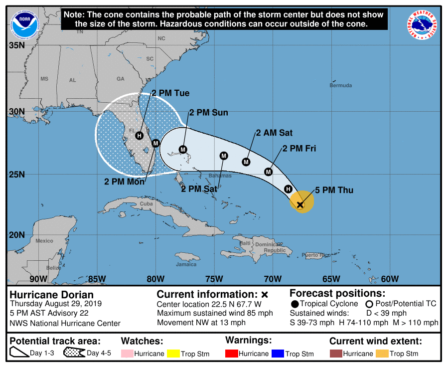
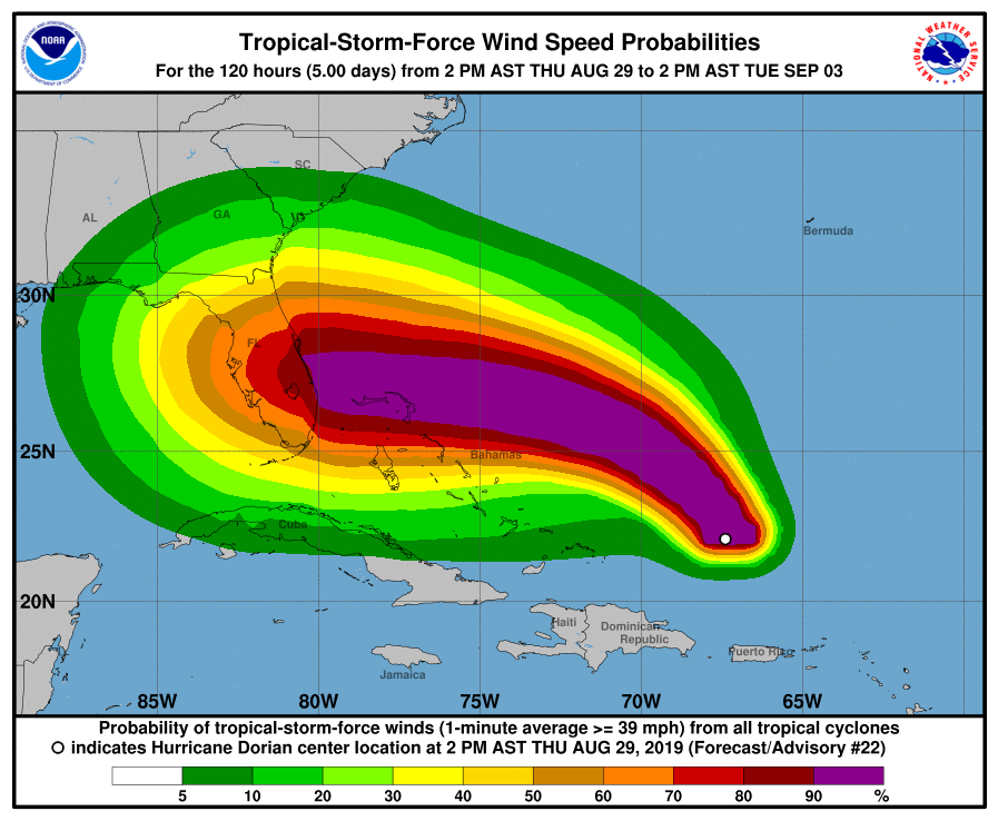
August 29, 2019, PM Update – The 5pm update from the National Hurricane Center shows no change in Hurricane Dorian’s intensity and no appreciable change in its track from this morning’s forecast. The storm is expected to intensify over the next two days to become up to a Category 4 hurricane (winds of 131-155 mph with storm surge of 13-15 feet). Landfall is expected sometime Monday anywhere at this point along Florida’s 500 mile long east coast. Effects could be felt beginning on Sunday.

Forecasters and state and local emergency management officials this evening are trying to address the dual threat of the storm: high wind and high water (from rainfall and storm surge). Both can be deadly. The flooding threat grew worse today, as forecasters noted indications that Dorian’s motion will slow on the approach. The slower the storm, the higher the storm surge on the coast and the greater the rainfall.
Coastal Flood Advisories have been in effect for Northeast Florida due to King Tides, with tides running about 1-2 feet above normal. Wherever Dorian tracks, the heaviest rainfall totals will follow. However, a widespread 6-12” of rain is expected across much of the state. Locally higher totals are possible, but it is too early to give specifics on rainfall totals.
The threat for significant river and flash flooding is increasing across the Florida Peninsula, regardless of the strength of Dorian. The rip current risk will be dangerously high for the holiday weekend at all Florida beaches.
County emergency managers that we talk to say they’ve been waiting on a surge forecast on which to base evacuation plans but that forecasters say it’s too soon to specify such surge. There are no tropical watches or warnings for Florida, but could be issued as early as Friday. Dorian could also expand in size as it moves toward the Florida Peninsula, which could increase the area of possible wind impacts.

There remains a possibility that during its slow down, the storm could make a sharp turn to the north. However, where that turn occurs remains uncertain. Forecasters noted at the 5pm update that the trend for any turn is actually a little to the south.
Because of the uncertainty of the storm’s path, Governor DeSantis this afternoon extended the State of Emergency for Hurricane Dorian to all 67 counties in Florida. The governor’s office noted the broader order provides state and local governments ample time, resources and flexibility to prepare as the exact landfall location of Hurricane Dorian continues to fluctuate. It also allows them to recoup preparation, response and recovery costs.
The state’s major power companies are warning state officials and the public to expect electric outages from Dorian’s expected strike. Duke Energy specifically, is telling Central Florida customers it expects damaged infrastructure that may result in extended power outages.
The Florida Office of Insurance Regulation (OIR) late this afternoon issued a notice to all health insurers, managed care organizations and other health entities licensed by OIR, reminded them the Emergency Order allows for early prescription refills. OIR has a dedicated seat at the state Emergency Operations Center to support response and recovery efforts. We will advise of any further OIR Orders that may be issued prior to or after the storm passes.
Meanwhile special needs shelters and in a few counties, regular shelters, are being planned for opening tomorrow into Saturday. Extra water and fuel shipments are being made to areas that have run out during preparations. Several counties anticipate issuing evacuation orders on Sunday
The Governor is urging all Floridians on the East Coast to prepare for impacts, including having seven days of food, water and medicine on hand. He said residents who don’t have a plan need to take time now to make one.
Click here for a full briefing with maps. Please prepare and be aware!
Lisa & the LMA team

