August 28, 2023 AM Update – All eyes and ears this morning will be on the National Hurricane Center’s 11am update to find out whether Tropical Storm Idalia has resumed its movement toward Florida and hopefully get a better idea just where it may make landfall as a hurricane on Florida’s Gulf coast mid-week. Forecasters late yesterday added “significant storm surge” to their list of predictions for Idalia. All 33 counties in the Governor’s Saturday State of Emergency Executive Order have begun implementing protective measures, with another 7 counties in Northeast Florida likely to be added to the list today. Potentially complicating matters this morning is a fuel contamination problem that could impact any evacuation plans by motor vehicle in the Tampa Bay area. Fuel purchased since Saturday morning at gas stations supplied by Citgo from the Port of Tampa has a strong likelihood of being contaminated with diesel fuel. This is the first of our updates on the storm, with daily evening updates to follow, including damage and insurance impacts.
As of 11pm last night, Idalia was still located nearly motionless between the Yucatan Peninsula of Mexico and Cuba. It is forecast to become a hurricane this evening as it reaches the southeastern Gulf of Mexico. The current forecast track has the center of the storm making landfall anywhere from Cape San Blas, which is west of Tallahassee, to Englewood, which is south of Sarasota around 7am Wednesday as a Category 2 hurricane. Their best estimate is somewhere in the middle, which would be rural and sparsely-populated Taylor and Dixie Counties. However, as we know, the northeast quadrant to a storm’s eye usually has the strongest, most damaging winds. Also, a third of the time, the storm travels outside the cone.
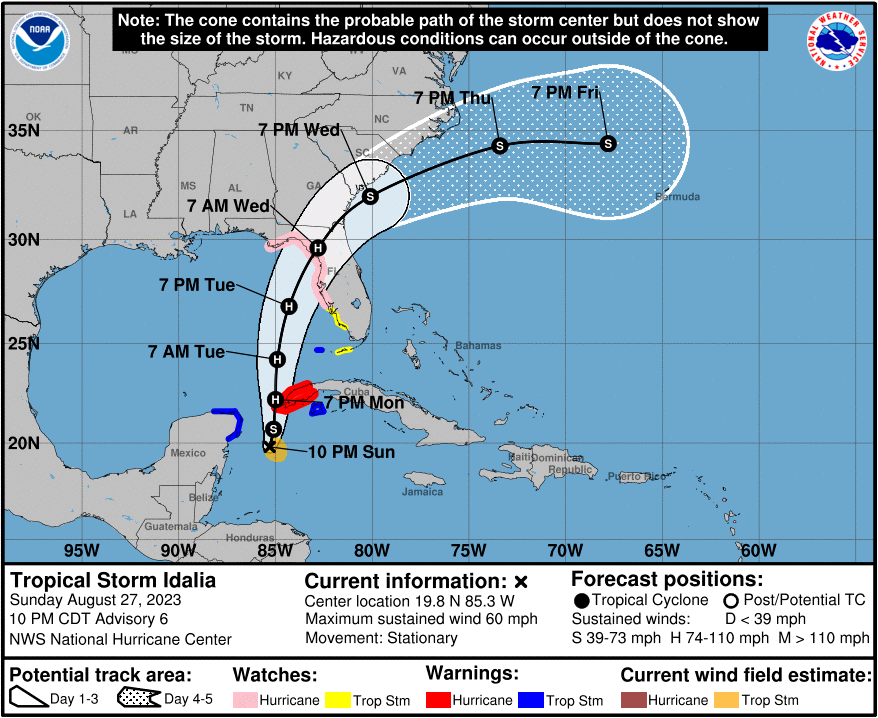
Current Warnings/Watches as of 11pm yesterday:
Hurricane Watch from Englewood to Indian Pass Florida, including Tampa Bay.
Tropical Storm Warning for Dry Tortugas Florida.
Tropical Storm Watch from South of Englewood to Chokoloskee Florida, and the Lower Florida Keys west of the west end of the Seven Mile Bridge.
Storm Surge Watch from Chokoloskee to Indian Pass Florida, including Tampa Bay.
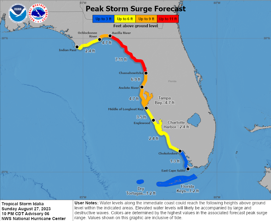
Storm surge of 7-11 feet in Taylor and Dixie counties are forecast. But note the orange line to the south in the chart below, which includes the populous areas of Pasco, Pinellas, and Hillsborough counties, including Tampa Bay. Storm surge there is forecast at a hefty 4-7 feet. This is considered by many to be the most flood vulnerable area of Florida – and by U.S. Census, is the most populated in Florida.
Florida Emergency Management Director Kevin Guthrie warned residents yesterday that hurricane and tropical storm force winds “will extend far beyond what the cone represents.” He also reminded us of the danger of storm surge. “Storm surge was the number one cause of deaths in Hurricane Ian. You can evacuate by going tens of miles away, not hundreds. Just simply going to your nearest shelter will save your life.” Guthrie urged residents to go to www.FloridaDisaster.org/know where they will be able to type in their home address to find out which flood evacuation zone they are in. Those not living in an evacuation zone and lacking a specific local evacuation order in this storm, can consider sheltering in place.
Forecasters warn, as with all developing storms, that “there is significant uncertainty in 3-4 day intensity predictions,” and to monitor changes in the forecast, advising that it’s better to be over-prepared than under-prepared. While the current forecast calls for a Category 2 hurricane, emergency managers we’ve talked to tell us they are planning as if it might be a Cat 3, just to be safe. The Governor has warned residents “that you could see impacts of the storm even if you live in a place outside the cone” and that those in the direct path of the storm should expect power outages. Electric companies have already started pre-staging linemen in the expected impacted areas.
In Leon County, home to Tallahassee, seven sandbag sites opened today (Sunday) to allow residents to fill-up their own sandbags for protection against home flooding.
The State Emergency Management Center in Tallahassee is going to Level One status of 24 hours a day operation beginning this morning. The Florida National Guard is mobilizing 1,500 personnel to respond and provide immediate support to impacted areas in addition to 2,400 high wheel vehicles and 12 aircraft. Many of the state’s storm response resources are being staged in Marion County, in Central Florida. (A complete list of mobilized resources as of this morning is at the end of this update.)
The Florida Department of Agriculture and Consumer Services (FDACS) has identified a potentially widespread fuel contamination caused by human error at the Port of Tampa. Any fuel purchased after 10:00 a.m. on Saturday August 27, at stations supplied by Citgo from the Port of Tampa has a strong likelihood of being contaminated with diesel fuel. You can read the press release here.
Click here for the full National Hurricane Center briefing with maps. You can also review our past Hurricane Updates and subscribe to receive future updates in your inbox.
Please know that we at Lisa Miller & Associates are here 24/7 for you. It may sound trite but we are all in this together, my friends and colleagues. Please prepare and be aware!
Lisa & the LMA team
(Here’s the latest news from the Governor’s Office on specific state preparedness actions and a list of mobilized resources:)
State Preparedness Efforts
- The Florida National Guard is mobilizing 1,500 personnel to respond and provide immediate support to impacted areas in addition to 2,400 high wheel vehicles and 12 aircraft .
- The Florida Department of Law Enforcement (FDLE) has activated the State Emergency Operations Center Team to support ongoing operations. FDLE has prepared:
- 25 officers ready to deploy.
- One mobile command vehicle;
- One operations command center; and
- Two mobile staging units.
- The Florida Fish and Wildlife Conservation Commission (FWC) has readied high-water vehicles and all other storm response resources statewide so they may be rapidly deployed to assist Floridians in need in the event of damage or flooding. Contingency plans based on forecasted landfall locations have been developed and are flexible based on the storm’s projected path.
- FWC Officers will respond with a variety of specialized equipment as necessary, including:
- Shallow draft boats;
- Larger platform vessels;
- ATVs;
- Airboats; and
- Four-wheel drive vehicles.
- These assets are in addition to local FWC officers deployed to potentially affected areas.
- FWC Special Operations Group (SOG) teams will serve as reconnaissance units for the State EOC and report back on damage after the storm has made landfall. FWC Aviation Section has been placed on standby and has readied all appropriate aircraft for potential deployment for EOC aerial assistance, reconnaissance, and post-storm damage assessments when needed.
- The Florida Highway Patrol has 300 troopers ready to deploy and is prepared to implement 12-hour Alpha, Bravo shifts in preparation for Tropical Storm Idalia.
- The Florida Department of Environmental Protection (DEP) has completed pre-storm beach surveys in all shoreline counties. Education
- Hernando County Schools will be closed Monday, August 28th, through Wednesday, August 31.
- Additional updates on school closures will be provided by the Florida Department of Education here.
Health and Human Services
- The Florida Department of Children and Families (DCF) is prepared to request early release of Supplemental Nutrition Assistance Program (SNAP) benefits depending on the severity of the storm.
- DCF’s Mass Care unit is working with the American Red Cross and feeding partners to assess shelter needs for food on hand for distribution.
- DCF is preparing resources to deploy as necessary for utilization of the crisis counseling program and deployment of crisis counseling teams to support area resiliency.
- The Department of Business and Professional Regulation (DBPR) Division of Drugs, Devices and Cosmetics stands ready to coordinate with wholesale distributors of prescription drugs and medical gas to ensure an uninterrupted supply for potential impacted residents.
- The Florida Department of Health (DOH) has distributed a statewide reminder regarding special needs shelter registration.
- DOH is working with local emergency management to prepare special needs shelter staffing.
- The DOH and Office of Insurance Regulation (OIR) sent information regarding early prescription refills permitted under Executive Order 23-171. This information was sent to the public, health insurers, managed care organizations, pharmacy benefit managers, pharmacy chains, and health care providers.
- DOH has contacted Medical Foster Care (MFC) families to enact emergency plans, prepare supplies, and fill any prescriptions. DOH staff will remain in contact with individual MFC families to ensure services and needs are met.
- AHCA opened an event in the Health Facility Reporting System ahead of any potential impacts, to receive daily updates from facilities.
- AHCA has contacted the Medicaid Managed Care Plans, to ensure they are taking the necessary preparations for the storm, including allowing for early prescription refills. Fee-for-service recipients are also eligible for early refills.
- The Agency for Persons with Disabilities (APD), has mapped out the locations based on the Governor’s Executive Order and current census of APD clients and residents located in potentially affected areas.
- Senior citizens and individuals with special needs or medically dependent individuals are encouraged to complete Florida’s Special Needs Registry to provide first responders and emergency management personnel with valuable information ahead of impacts from Tropical Storm Idalia.
Infrastructure, Roads and State Closures
- The Florida Department of Agriculture and Consumer Services (FDACS) has identified a potentially widespread fuel contamination caused by human error at the Port of Tampa. Any fuel purchased after 10:00 a.m. on Saturday August 27, at stations supplied by Citgo from the Port of Tampa has a strong likelihood of being contaminated with diesel fuel. Read the press release here.
- FDACS has opened up the consumer hotline to receive complaints from impacted consumers. If you believe you were sold contaminated gasoline, you can file a complaint by calling 1-800-HELP-FLA or visiting fdacs.gov.
- Florida Department of Transportation (FDOT) team members are readying equipment and vehicles in case of the need for pre-staging and immediate deployment.
- The Howard Franklin Bridge project in Tampa is securing barges in the area. All other active construction projects are on alert and standing ready to implement any necessary actions related to storm preparations.
- Port Tampa Bay, Seaport Manatee, and Port of St. Petersburg have begun securing port infrastructure and clearing waterways.
- FDOT is in close communication with transportation partners across the state, including airports, seaports, rail lines and transit agencies, as they are on watch and making any necessary preparations.
- Florida’s 511 Traveler Information System is available for drivers to stay informed about roadway conditions during emergencies. This service is monitored and updated 24/7 by FDOT and includes traffic conditions, road and bridge closures, and other specialized alerts. To use Florida’s 511, visit the website at FL511.com or download the app—on both Apple and Android devices.
- Currently, no Florida State Parks are closed.
- The Department of Environmental Protection (DEP) has published a storm updates webpage to keep state park visitors updated of potential closures: FloridaStateParks.org/StormUpdates.
Resources for Employees and Businesses
- The Florida Department of Commerce activated the Florida Private Sector Hotline (850-815-4925) today, August 27 at 12:00pm. Inquiries may also be emailed to [email protected].
- The Florida Department of Commerce has alerted the statewide Community Action Agency (CAA) Network and Local Workforce Development Boards (LWDBs) to initiate disaster preparedness activities. LWDBs and CAAs have been advised to submit their anticipated cash needs to ensure critical services to Floridians are not disrupted.
- The DBPR Division of Hotels and Restaurants is coordinating and preparing emergency response teams in all seven district offices statewide for a post-storm rapid response to assist lodging establishments and restaurants in reopening as necessary.
Emergency Orders
- FLHSMV EO 082623 has been filed, which provides for certain commercial vehicles under the original thirty days that are providing direct assistance due to the state of emergency. The emergency order also waives replacement fees and defers administrative actions related to the issuance/replacement of credentials, i.e., identification cards, driver licenses or vehicle or vessel registrations or titles, etc., based upon inclement weather or office closures.
- Following the issuance of the Governor’s Executive Order, DEP has issued an Emergency Final Order waiving permitting requirements for the storage and processing of solid waste, including hurricane debris.
- DEP’s Emergency Final Order also removes barriers for expediting necessary repair, replacement and restoration of structures, equipment, surface water management systems, works and other systems that may be damaged by the storm.
Tropical Storm Idalia Update of August 28, 2023, AM Update